Tornado tracker: How David Sills is uncovering Canada’s shifting storm patterns
5 Minute Read
David Sills has spent his career chasing the truth behind Canada’s most extreme weather. As director of the Northern Tornadoes Project (NTP) at Western University, he leads a national effort to detect and understand tornadoes, downbursts, and derechos—events increasingly affecting Ontario and Quebec.
Sills’ fascination with storms began early. Growing up in Windsor, ON, he was captivated by powerful systems rolling in from the U.S. “There was a big weather event in 1980 that levelled all of our woodlot’s trees,” he recalls. “It was part of a larger tornado and downburst outbreak that hit the U.S. and southern Ontario.”
That moment—green skies, bending trees and a scramble to the basement—left a lasting impression. “We’d often see big storms develop near Detroit but weaken over Windsor. I was always curious why, and that became part of my PhD thesis. Lake Erie really protects areas north of it. The Great Lakes have a huge influence on storm development. You can see it in the data.”
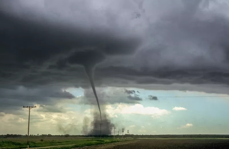
Sills holds a doctorate and multiple credentials in atmospheric science. After two decades as a severe weather scientist with Environment and Climate Change Canada, he now tracks storms in real time as part of his work with the NTP—recently photographing one of Ontario’s two tornadoes so far this year. “Tornadoes are usually on the ground for just minutes. I filmed one in July at Lucan from start to finish in three.”
Climate, data and the shifting storm landscape
Since launching in 2017, the NTP has improved tornado detection, advanced severe weather research and built Canada’s most comprehensive tornado database. In 2024, it became part of the new Canadian Severe Storms Laboratory (CSSL), backed by a $20-million investment from ImpactWX. The lab now also houses research on hail and mesonet data—high-resolution weather observations from dense ground sensor networks.
“Our goal is to make all the data open and accessible,” says the meteorologist. “There’s a dashboard where we map every tornado. You can filter and download the data.”
A quieter year for tornadoes in Ontario
As of late July, the NTP has confirmed 34 tornadoes across Canada—a sharp drop from previous years. Tornadoes in Ontario have been limited to two, the lowest count since the project began. Saskatchewan leads with 17 tornadoes.
In 2024, the NTP recorded 129 tornadoes and 86 downbursts nationwide. Ontario led with 60 tornadoes (including 10 over water), followed by Quebec with 21. The team investigated more than 500 severe weather events. While no EF3 or EF4 tornadoes were recorded, 12 EF2s marked a notable increase.
Tornadoes are rated using the Enhanced Fujita (EF) scale, from EF0 to EF5. While EF4 and EF5 tornadoes are rare and devastating, powerful downbursts can reach EF3 intensity—less severe but still destructive.
Each year brings a different pattern. “Ontario’s cool, wet spring may have played a role. We’ve had heat lately, but not the right ingredients for big tornadoes. Even the ones we’ve had have been weak. So, we’ve been lucky—but tornadoes are only one aspect of severe weather.”
Is climate change shaping Canada’s severe weather?
Sills is investigating whether tornado activity is shifting eastward—a trend bringing more severe weather to Ontario and Quebec. But he’s cautious about attributing it directly to climate change. “The smaller the scale of the phenomena, the harder it is to connect it to climate change,” he says. “You need a lot of data and occurrences.”
Still, signs are emerging. As Canada’s climate warms, the storm season may stretch beyond its traditional June-to-August window. “Warm weather is a key ingredient,” says Sills. “And as it stretches out, there’s more opportunity for storms.”
But more heat doesn’t always mean more tornadoes. “The dry air masses in the West are fuelling wildfires, which generate smoke that spreads across the country,” he says. “That smoke blocks sunlight that feeds thunderstorms. In smoky years, we’re seeing fewer storms and tornadoes.”
It’s a paradox: Climate change may increase drought, heat and wildfires—yet those same conditions could suppress tornado formation. “We’re building datasets and looking for robust trends,” says Sills. “There’s a suspected climate influence, but no smoking gun yet.”
Derechos: Canada’s emerging wind threat
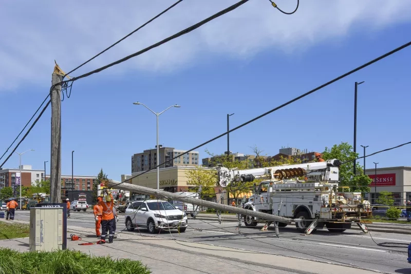
One growing concern is the derecho—a fast-moving windstorm capable of damaging vast areas. “As more heat domes form in the U.S., we’re seeing more derechos ride along their edges,” Sills says. “In 2022, one moved north from the eastern U.S., affecting 40 per cent of Canada’s population.”
With heat domes becoming more frequent, derechos may follow. “There’s been even less research on derechos than tornadoes,” says Sills. “We’ve just hired a derecho expert from Europe to lead a new project.”
Currently, the derecho hotspot is the upper Midwest in the U.S., but shifting conditions could make the Great Lakes and Quebec next. “We get asked about this a lot,” says Sills. “We’re working as fast as we can—but we don’t even have an official list of derechos in Canada yet.”
Comparing tornadoes, derechos and downbursts
While all three are dangerous wind events, they differ in formation and damage patterns:
-
Derecho—Spanish for “straight”—is a large-scale windstorm with powerful, straight-line winds. Formed by clusters of downbursts, derechos can span thousands of kilometres and spawn small tornadoes.
-
Tornado—from the Spanish tornar, meaning “to turn”—is a rotating column of air extending from a thunderstorm to the ground. It causes intense, localized damage with a narrow path of converging debris.
-
Downburst winds result from rapidly cooled air dragged downward by heavy precipitation. Upon impact, winds spread outward in a dramatic “splash-down” effect, pushing debris across several kilometres.
While derechos are hard to avoid, sheltering inside a house or vehicle is generally safer. Tornadoes often come with more lead time—typically four to six hours between a watch and a warning.
How tornado alerts work—and why public reports matter
Tornado warnings are issued by Environment Canada through the Alert Ready system, which sends notifications to cellphones and overrides radio and TV broadcasts.
Radar helps track tornado formation, but public reports are vital. Sightings can be reported by calling Environment Canada or emailing ONstorm@ec.gc.ca.
For Sills, weather is more than a profession—it’s a lifelong passion. His work with the NTP serves both science and public safety: “A lot of people in this field get bitten by the weather bug early in life. It’s more like a lifestyle than an occupation.”
For more articles and resources about extreme winds and protecting your home, visit caaneo.ca/severe-winds.